GPS : 45.44516, -64.175519
The hike down into the gorge is tough but rewarding. Hiking less than 1km to the rivers edge before turning upstream and walking just 50ms to an 80ft waterfall with a very large pool at its base. Being this deep into the gorge provides a beautiful sight of the high walls on each side as the rivers bleeds downstream. The main falls here are approx 80ft in height and fall at 90 degrees. If you would like to travel upstream you will encounter 3/4 more large falls. This river has it all.
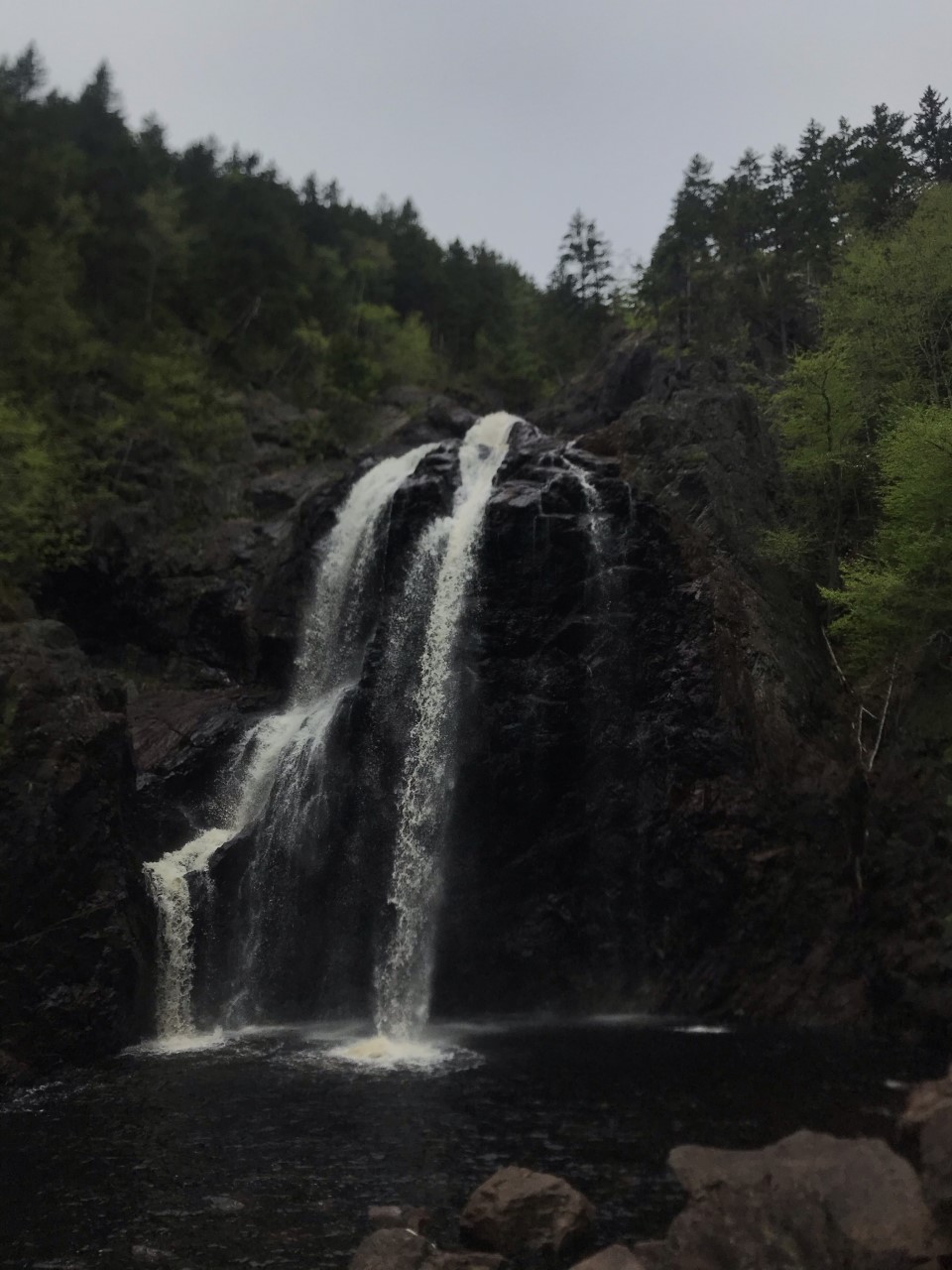


Important Information – The main fall is the tallest on mainland NS. It is worth the hard trek down into the gorge to view it. The trail down is very well marked and easy to follow but it can be very steep at times. Take your time. At the base of the main fall and the other falls upstream expect to be able to swim and possible jump if you so choose. From the trail head you will enter the forest on a human trafficked trail. Expect to walk on exposed tree roots, rocks, and dirt/mud. The trail is very well marked with flagging tape. Approx 400ms into your hike down you will come to a T-Intersection, going left and right. The left option will have you travel upstream and on top of the main fall. The trail to the right is the trail you want to take to reach the base of the main fall. no longer than 300ms down the right trail will have you reaching the rivers edge. From here turn upstream and walk no more than 50ms to the base of the main falls. If you will like to travel upstream and view the other falls you can do so in two ways. Go back the way you came and choose the left option at the T-Intersection which will now be going straight if coming up from the base of the falls or you can ascend up the other side of the gorge on a very loose surface to the right of the falls. At the top of the ascent there is a marked trail leading you left. Following this trail to the top of the main fall. At this location you can see a 20 ft feeder fall into a nice pool that feeds the main fall. To your right upstream approx 100ms is another massive fall. This fall has multiple drops and a large pool. In total it will be around 50 ft in height and falling mostly at 80 degrees. Simply walk upstream on the right hand side to get a closer view of this fall. Now, from here if you wish to travel upstream to see another 2 falls you will want to cross the river where you deem best. You will see flagging tape approx 50 ft upstream from the top of the feeder fall into the main fall. Traveling up hill for a short distance before turning right and walking the gorges edge. No more than 500ms forward you will see the trail start to head down hill again. This will bring you to another large fall approx 20ft in height and falling at 90 degrees. From here you can follow the trail you took down into the gorge back to the trail head. There is no need to reach the top of the main falls feeder fall and cross the river than travel back down to the main falls base. Simply stay on the gorges edge and it will connect you back with the main trail you took down the hill at the T-Intersection or a little higher.
Directions – These falls are along East Branch Moose River in Five Islands area. If you are leaving from Halifax, you will want to get on Highway 103 (Veteran’s Memorial Highway) heading towards Truro. Taking Exit 14A and turning left towards Onslow at the end of the off ramp on Highway 4. Following Highway 4 to the roundabout just past Masstown Market. Exiting left out of the roundabout to remain on Highway 4. Driving until you reach the junction with Highway 2 on your left. Turn left onto highway 2 and drive towards Economy and Five Islands. Continuing along Highway 2 until you reach a logging road on your right. This logging road has a wide opening, it is just after where East Branch Moose River crosses under the road, and it is just after the left turn for Tidal River Ridge Retreat. The logging road has a wide mouth and will start off veering right then left going uphill. You will drive this logging road for 4.5kms until you reach a right turn. It is your 4th right turn along the logging road. Once you have turned at this location, follow this logging road for approx 3kms. At this point you will see flagging tape and markers on your left indicating the trail head. Just beyond the trail end is a cul de sac like section for you to turn around or park. Enter the trail and turn right at the T-Intersection to reach the base of the main falls or turn left and head upstream to the other falls.
